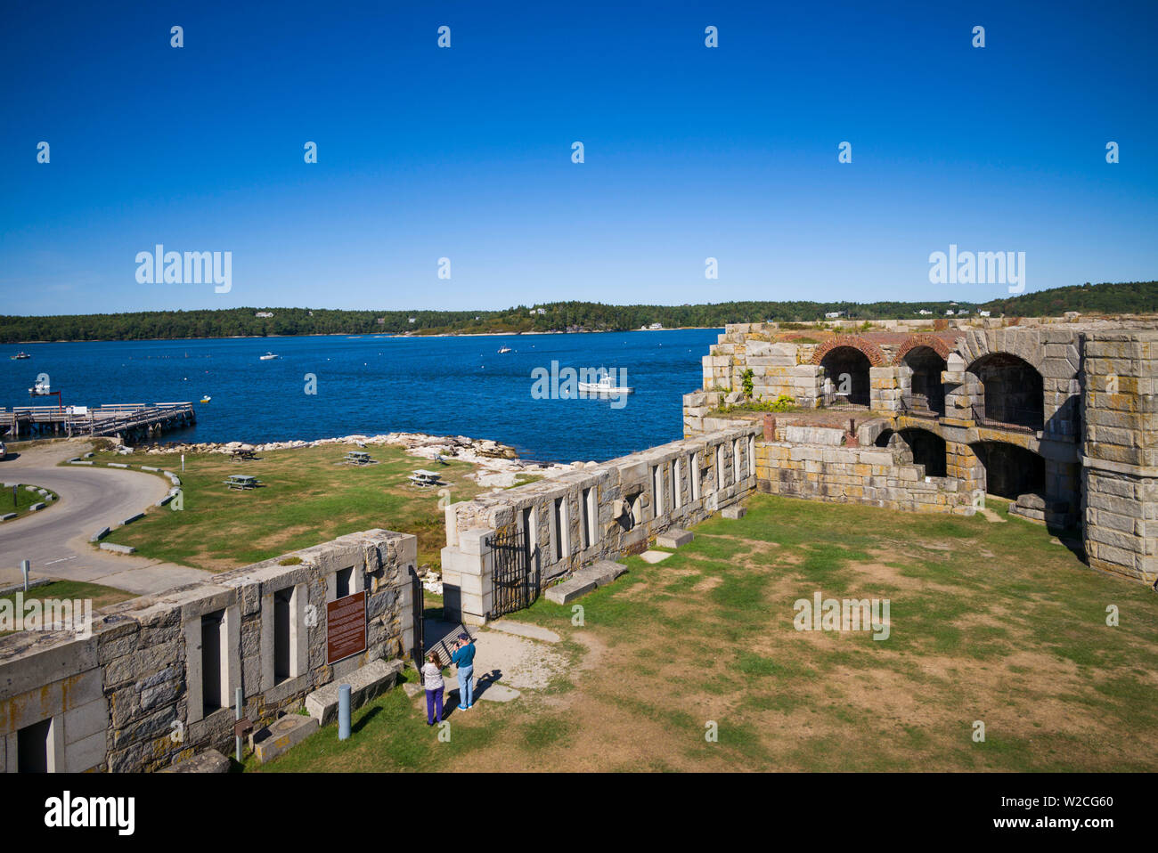
You’re driving down Route 209 in Maine, winding through Phippsburg, and the salt air starts to get heavy. The trees thin out. Then, suddenly, this massive, semi-circular stone beast appears where the Kennebec River hits the Atlantic. It’s huge. It looks like something out of a medieval fever dream, but it's actually Fort Popham State Historic Site. Honestly, if you just pull up, snap a photo of the granite blocks, and leave, you’re missing the weirdest parts of the story.
Most people think of Civil War forts as these completed, heroic monuments. Not this one. Fort Popham is essentially a massive, unfinished construction project that took way too long to build and was obsolete before the mortar even dried. It’s a beautiful, echoing failure of 19th-century military engineering that happens to be one of the coolest spots on the Maine coast.
The Fort That Never Quite Finished
Construction started in 1862. The Union was panicked. Southern privateers and foreign navies—specifically the British—were a legitimate threat to the shipyards upriver in Bath. If you control the mouth of the Kennebec, you control the heart of Maine’s industry. So, the government started stacking massive blocks of granite.
They used granite from nearby islands like Fox Island and even some from Dix Island. The craftsmanship is honestly insane. You walk into the casemates today and you can still see the tool marks from the stonemasons. But here’s the thing: they never actually finished the second tier. By the time they were making real progress, the Civil War ended. The "Third System" of coastal defense—the philosophy behind these big masonry forts—was basically dead.
Why? Rifled cannon.
Old-school smoothbore cannons couldn't do much to thick granite. But rifled guns? They could whistle a shell right through these walls. The engineers realized that Fort Popham was basically a giant, expensive target. They stopped work in 1869, leaving it in the "half-done" state you see today. It’s kinda haunting to see the stairs that lead to nowhere and the spots where the third level of guns was supposed to sit.
What Most People Get Wrong About the Location
If you look at a map, you’ll see the fort sits on Atkins Bay. But the real history of this patch of sand goes back way further than the 1860s. Directly adjacent to Fort Popham State Historic Site is the site of the 1607 Popham Colony.
This is a big deal.
Most Americans are taught that Plymouth or Jamestown were the "firsts." But the Popham Colony (Fort St. George) was right here. It failed after just one brutal Maine winter, mostly because the leader, George Popham, died and the other leader, Raleigh Gilbert, inherited an estate back in England and decided he’d rather be rich in the UK than freezing in Maine.
You can’t actually see the 1607 colony ruins—they’re mostly archaeological footprints now—but standing on the ramparts of the granite fort gives you the exact same view those 17th-century settlers had. It’s a heavy feeling. You have these overlapping layers of "failed" or "abandoned" history all in one spot.
Walking Through the Granite Labyrinth
Walking into the fort is free-flowing. Unlike some state sites that funnel you through a gift shop, Popham feels raw. It’s a series of interlocking arches. The acoustic properties inside the casemates are wild; you can whisper on one side of a gallery and someone forty feet away will hear you like you’re standing right next to them.
The spiral staircases are the highlight. They’re made of cantilevered granite steps. No central pillar. Just physics holding them up.
- The lower level housed the heavy guns.
- The "hot shot" furnace is still there. This was a brick oven used to heat cannonballs until they were red-hot so they would set wooden enemy ships on fire.
- You’ll notice the 10-inch and 15-inch Rodman guns were the intended residents here.
- The parade ground in the center is now just a grassy patch where kids run around, but it was meant to be the bustling heart of the garrison.
Actually, the fort was briefly reactivated for the Spanish-American War and World War I. They didn't use the old granite walls for the big guns then, though. They built newer, uglier concrete batteries nearby because, again, granite doesn't like modern explosives.
The Secret Season to Visit
If you go in July, it’s a zoo. The parking lot fills up with people heading to Popham Beach State Park down the road. You’ll be fighting for a spot and the "ghostly" atmosphere of the fort is kind of ruined by kids eating ice cream and seagulls screaming.
Go in October.
The wind off the Kennebec is biting, sure, but the light hits the granite in a way that makes it look golden. The fog rolls into Atkins Bay and suddenly the fort looks like it’s floating. It’s quiet. You can hear the tide pulling through the "Sugarloaf" islands just offshore. That’s when the history actually feels real.
Practical Insights for Your Trip
Don't just plug the name into your GPS and hope for the best. Phippsburg is a peninsula, and there is one road in and one road out.
- Check the Tides: At low tide, the beach around the fort expands significantly. You can walk way out and look back at the fort’s crescent shape. It’s the best angle for photos.
- Bring a Flashlight: Some of the inner magazines and powder rooms are pitch black. Your phone light works, but a real beam lets you see the architectural details in the ceiling.
- Footwear Matters: This is old stone. It’s uneven, it’s often wet, and there’s moss. Don't wear flip-flops if you plan on climbing the spiral stairs.
- The "Double Feature": Don't forget to look across the water at Fort Baldwin. It’s up on the hill. Most people skip it because it requires a short hike, but it’s the "modern" (early 20th century) counterpart to Popham.
Fort Popham State Historic Site isn't a museum where things are behind glass. It’s a tactile experience. It's a place where you can touch the iron gates that are slowly rusting into the stone and realize that nature is eventually going to win this fight.
How to Make the Most of the Visit
Pack a lunch. There aren't many places to grab food once you're deep into Phippsburg, especially in the off-season. Spinneys is right there and great for a sit-down meal, but for a quick bite, you’ll want to stop in Bath on your way down.
When you get to the fort, walk all the way to the top level. Look east toward Seguin Island Light. On a clear day, you’re looking at one of the most treacherous and historic stretches of water on the Eastern Seaboard.
Actionable Next Steps
- Map the Route: Take I-295 to Bath, then follow Route 209 south. It’s about a 25-minute drive from the center of Bath.
- Verify Hours: While the grounds are often accessible, the interior of the fort officially opens Memorial Day through September 30th. Check the Maine Bureau of Parks and Lands website if you’re heading there late in the year to ensure the gates are open.
- Gear Up: Bring a windbreaker regardless of the forecast. The "Kennebec Funnel" creates a wind chill that is consistently 10 degrees colder than it is five miles inland.
- Document the Details: Look for the "broad arrow" marks or mason signatures on the granite blocks near the entrance—they are small, hidden pieces of history that most visitors walk right past.